The Planetary Boundary Layer
The planetary boundary layer hugs the earth’s surface. It’s where much of the action takes place.
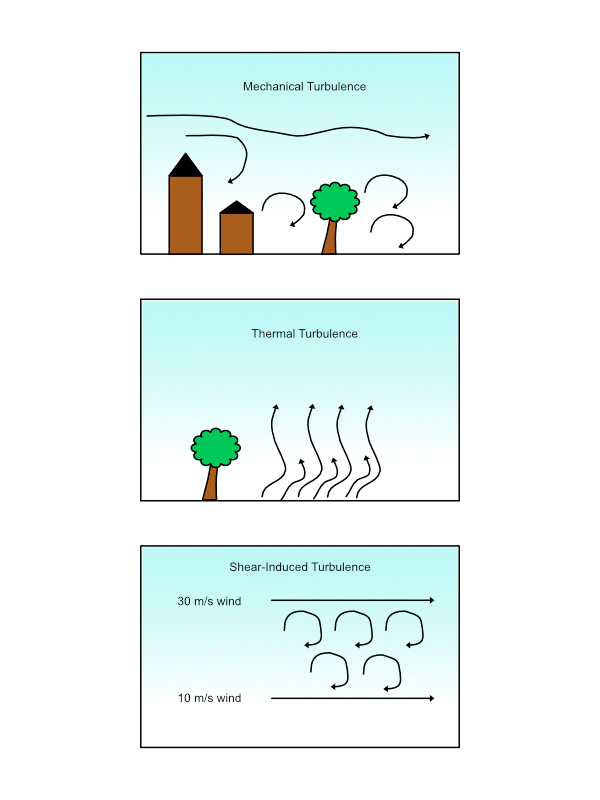
When asked to list the layers of the atmosphere, most people begin with the troposphere, the tropopause, the stratosphere, the stratopause, up to the top. There is, however, a frequently overlooked layer, the one closest to the earth’s surface. Known as the Planetary Boundary Layer (PBL), occasionally the Atmospheric Boundary Layer, and technically the peplosphere, the PBL is a dynamic layer of the atmosphere in direct contact with the earth’s surface. It is heavily influenced by temperature, convection, and friction with terrain, forests, buildings, and the ground itself. The effects within the PBL are so important that architects must take them into account when designing tall buildings. The PBL is well-mixed, with turbulence generated primarily by wind shear, since the wind at the top of the PBL is geostrophic and at the surface near zero. Temperature gradients can generate turbulence (thermals) or suppress it (inversions). Low-level turbulence can also be caused by structures and plants.
The PBL is unique among the atmospheric layers in that it is quickly influenced by heating and cooling, mixing, wind shears, and diurnal differences. Conditions can change in as little as thirty minutes.
The PBL is where most pollution is trapped. Because it is in contact with vegetation, turbulent transport and advection move water and oxygen to and from plants. The PBL is also a major supplier of energy for thunderstorms. Weather is changed and maintained in the boundary layer. And, you spend the majority of your life in it.
Structure of the PBL
The PBL consists of three primary layers: the surface layer, the thin layer bound to the surface; the mixed layer, the middle layer which contains most of the thermal and mechanical turbulence and mixing; and the cap or entrainment zone (basically an inversion), the top layer where air is entrained or dragged to the lower levels by air from thermals that have cooled and are settling back down to the surface.
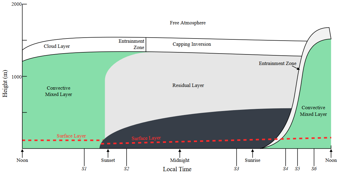
The PBL extends from the surface to approximately 1.5 kilometers (3000 feet) above the earth. The depth of the PBL is shallower at night when there is little mixing and the cooling atmosphere becomes more stable and dense as the evening progresses. In some cases, the PBL can get so thin it almost disappears. At sunup, thermal heating transfers heat to the atmosphere next to the surface, convective motion transfers heat to the lower atmosphere and the PBL expands. Meanwhile, the atmosphere above the PBL remains more uniform.
Conditions within the PBL can be considered micrometeorological in nature, i.e. on a very small, localized scale. Micrometeorology involves space scales smaller than 3 kilometers and time scales less than one hour. This would include mechanical turbulence, plumes, thermals, wakes, cumulus clouds, and of course boundary layers. Boundary layer clouds consist mostly of fair-weather cumulus, stratocumulus, and fog.
The Boundary Layer Cycle
Let’s take a look at a typical clear air 24-hour period to see how the PBL responds to changes in local environment.
Sunup
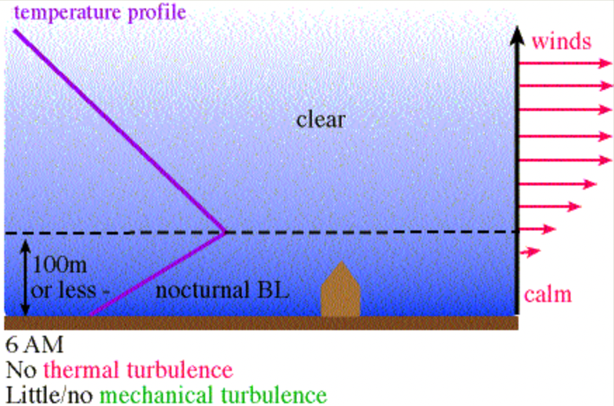
At sunrise the atmosphere has cooled all night and is relatively shallow (around 100 meters) and stable. The wind is usually calm and there is very little thermal or shear turbulence and mixing within the layer. As the sun rises the earth begins to warm. The earth’s radiation warms the air next to the the surface and weak thermals begin to rise. The nighttime inversion mixes out and weakens. As thermals rise, air advects in to replace it, creating winds. The winds interact with terrain, trees and plants, and structures, creating weak turbulence.
Mid-day
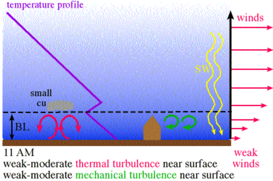
By noon, heating has increased. The air in the surface layer is well-heated and thermals have strengthened. Wind increases and air advects in from the surroundings to replace the rising thermals. As the thermals rise and cool, a counteracting downdraft is created by the subsiding cool air and a cycle of rising and falling air is established. Air parcels that break through the top of the boundary layer may form fair weather cumulus. At this point, the PBL is approximately one kilometer deep.
Mid-Afternoon
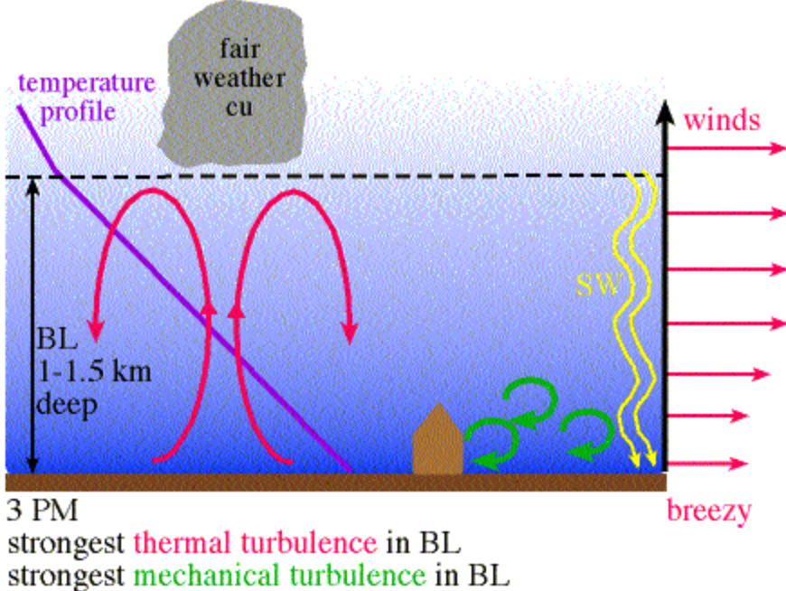
By 3:00 PM, circulation is well-established. The PBL, now around 1.5 km deep, is turbulent from top to bottom and the atmosphere is completely mixed near the earth. Fair-weather cumulus may be well established above the PBL.
Sunset
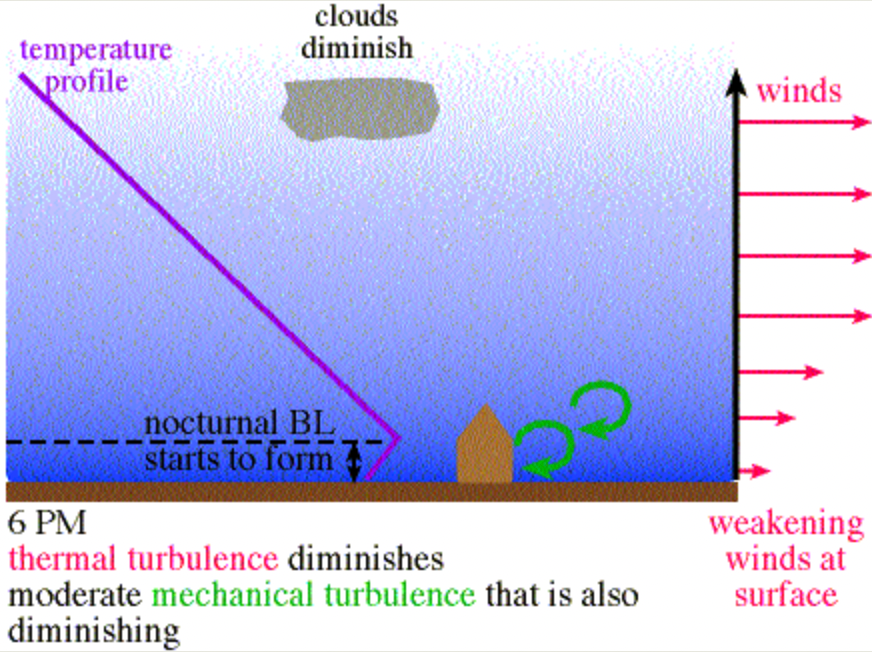
At sunset, the longwave radiation from earth to space exceeds the incoming radiation from the setting sun and the earth begins cooling, as does the lowest layer of the PBL. As evening wears on into darkness, this process continues. The air in the PBL gets steadily colder and denser and more stable and the boundary layer as a whole gets shallower. The nighttime inversion may form a cap. There is little circulation and little vertical motion. This process continues through the night until sunrise, when the cycle begins anew.
The preceding scenarios assume a relatively homogeneous atmosphere with no low or high pressure systems or frontal boundaries moving through.
Winds in the Planetary Boundary Layer
The portion of the PBL nearest the earth’s surface is the most tightly bound to the earth and can be considered calm, much like the layer of air immediately next to your windshield. Because the air molecules are bound to the windshield by friction, dust will not blow off the windshield no matter how fast you drive. The farther you get above the windshield the more force the air flow has, up to the speed of the car, assuming a calm day.
Wind has three means by which it moves within the boundary layer; mean wind, waves, and turbulence. Mean wind is simply the average wind, which generally increases with altitude. Mean wind is primarily responsible for horizontal transport. Waves form downwind of obstacles such as hills or trees. Turbulence results when the mean wind is radically disturbed by surface objects or surface heating and is the primary source of vertical movement. Turbulent transport may be in the form of eddies, which are gusts of wind in the vertical plane and can carry heat, momentum, water vapor, and carbon dioxide. Turbulence may be as small as a few molecules or dominate the entire boundary layer.
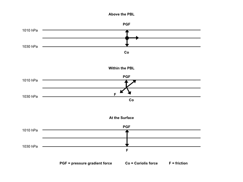
Near the surface, pressure gradient force, the pressure caused by a difference in air pressure from one location to another, is counterbalanced by friction.
Wind increases steadily as you get farther above the surface. The wind is a combination of pressure gradient force counterbalanced by Coriolis force and friction. Wind will tend to blow at an angle across the pressure gradient from higher to lower pressure.
Finally, as you get into the atmosphere above the influence of the PBL, called Free Atmosphere, the wind becomes geostrophic; pressure gradient force is balanced by Coriolis force. Friction at that altitude has little or no effect, and the wind blows follows the isobars.
In the regions of the Mountain West, the elevations extend the PBL higher into the atmosphere, but still only about 1.5 km above the surface, after which the effect of the Free Atmosphere takes over. For meteorologists, studying the boundary layer becomes extremely difficult when it lies over complex terrain, such as tall mountains. For this reason, the 500mb (18,000 MSL) upper atmosphere chart is used to evaluate geostrophic flow, vorticity, and shear, free from the turbulence of the PBL.
